Geolocating a random island using geometry and CUDA programming
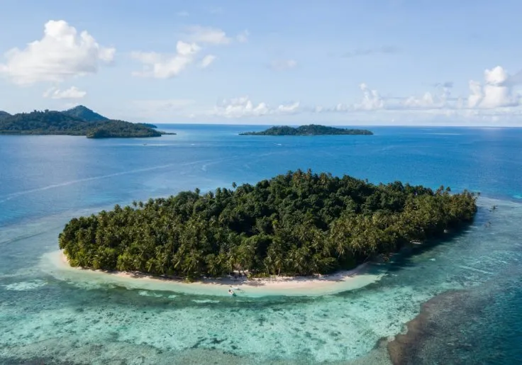
A geometry- and GPU-based geolocation process identified Oan resort on an islet in the Federated States of Micronesia as the location in Gralhix OSINT Exercise #004. The islet’s coordinates are 7.363444° N, 151.755750° E, and the camera was determined to face northwest, at a bearing of about 324.97°. The process found no useful EXIF or GPS data in the 736-by-515 WEBP image. It modeled three visible landmasses as a triangle, then searched OpenStreetMap’s 882 MB global land-polygon dataset for matching island configurations. Tropical-latitude, local-density, clustering, geometric, open-water, coral-cay-shape, vegetation, and elevation filters reduced more than 80.69 million candidate island triplets to 26. An NVIDIA GeForce RTX 3050 evaluated the initial 80.7 million triples in 204.1 milliseconds using one CUDA thread per triple, producing 158,784 initial matches. Further checks used Sentinel-2 imagery from Element84’s Earth Search catalog to require a normalized difference vegetation index above 0.6, and Copernicus GLO-30 elevation data to require a low resort islet and nearby terrain between 100 and 500 meters high. Manual satellite-map inspection of the final candidates selected the Micronesian location.
yassa9.github.io
10 min
8/19/2026
Geolocating a random island using geometry and CUDA programming
A geometry- and GPU-based geolocation process identified Oan resort on an islet in the Federated States of Micronesia as the location in Gralhix OSINT Exercise #004. The islet’s coordinates are 7.363444° N, 151.755750° E, and the camera was determined to face northwest, at a bearing of about 324.97°. The process found no useful EXIF or GPS data in the 736-by-515 WEBP image. It modeled three visible landmasses as a triangle, then searched OpenStreetMap’s 882 MB global land-polygon dataset for matching island configurations. Tropical-latitude, local-density, clustering, geometric, open-water, coral-cay-shape, vegetation, and elevation filters reduced more than 80.69 million candidate island triplets to 26. An NVIDIA GeForce RTX 3050 evaluated the initial 80.7 million triples in 204.1 milliseconds using one CUDA thread per triple, producing 158,784 initial matches. Further checks used Sentinel-2 imagery from Element84’s Earth Search catalog to require a normalized difference vegetation index above 0.6, and Copernicus GLO-30 elevation data to require a low resort islet and nearby terrain between 100 and 500 meters high. Manual satellite-map inspection of the final candidates selected the Micronesian location.
yassa9.github.io
10 min
8/19/2026
Geolocating a random island using geometry and CUDA programming
A geometry- and GPU-based geolocation process identified Oan resort on an islet in the Federated States of Micronesia as the location in Gralhix OSINT Exercise #004. The islet’s coordinates are 7.363444° N, 151.755750° E, and the camera was determined to face northwest, at a bearing of about 324.97°. The process found no useful EXIF or GPS data in the 736-by-515 WEBP image. It modeled three visible landmasses as a triangle, then searched OpenStreetMap’s 882 MB global land-polygon dataset for matching island configurations. Tropical-latitude, local-density, clustering, geometric, open-water, coral-cay-shape, vegetation, and elevation filters reduced more than 80.69 million candidate island triplets to 26. An NVIDIA GeForce RTX 3050 evaluated the initial 80.7 million triples in 204.1 milliseconds using one CUDA thread per triple, producing 158,784 initial matches. Further checks used Sentinel-2 imagery from Element84’s Earth Search catalog to require a normalized difference vegetation index above 0.6, and Copernicus GLO-30 elevation data to require a low resort islet and nearby terrain between 100 and 500 meters high. Manual satellite-map inspection of the final candidates selected the Micronesian location.
yassa9.github.io
10 min
8/19/2026
No more articles to load